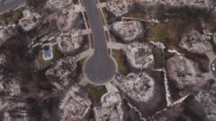
Aerial reconnaissance following major wildfire events reveals distinct failure modes in modern suburban infrastructure. When uncrewed aerial systems capture high-resolution imagery of disaster zones like Spokane, visual media often focuses on the sheer scale of the tragedy. Beneath the visible ash lies a complex mechanical process of structural ignition, ember transport dynamics, and regional vulnerability factors. Evaluating these events requires stripping away emotional reporting to examine the physical variables that dictate whether a residential structure survives or fails.
The Three Vectors of Residential Ignition
Wildfires do not destroy communities through a single mechanism. Property loss is the product of three distinct physical vectors acting independently or in combination during a passing firefront.
Radiation and Convection
Direct flame contact accounts for a smaller percentage of home losses than commonly assumed. Instead, radiant heat from burning vegetation or adjacent structures transfers thermal energy across open space. When radiant heat flux exceeds critical thresholds for glass and wood siding, spontaneous pyrolysis occurs without direct spark contact. Convective heat transfer then drives superheated air currents upward and outward, pre-heating adjacent fuel sources and accelerating total combustion.
Firebrand Shower Mechanics
Long-range spotting drives the rapid spread of wildland-urban interface fires. Burning embers, or firebrands, are lofted into the convective column of the main fire, catch upper-level winds, and travel miles ahead of the flame front. When these embers land on vulnerable building assemblies, such as dry wood mulch, accumulated pine needles in roof valleys, or unsealed attic vents, secondary ignition points multiply exponentially. Aerial photography frequently isolates these isolated pockets of total destruction surrounded by untouched properties, illustrating the stochastic nature of ember dispersion.
Structure-to-Structure Propagation
Once a single home ignites, it transitions from a receptor of wildland fuel to a primary emitter of thermal energy. High-density residential zoning creates fuel continuity where houses act as larger, more energy-dense logs. Radiant heat from one burning garage can ignite neighboring vehicles and siding across standard property setbacks, creating a self-sustaining urban conflagration independent of the original wildland fire progression.
The Cost Function of Urban-Interface Vulnerability
Mitigating property loss in wildfire-prone zones involves balancing construction costs against probability of exposure. Standard building practices historically prioritize weather resistance over thermal isolation. Retrofitting an existing property to withstand high-intensity ember showers requires systematic hardening across vulnerable envelope components.
Roof assemblies represent the primary vulnerability threshold. Class A fire-rated roofing materials provide baseline defense against falling firebrands, but eaves and overhangs often feature unblocked ventilation gaps designed for climate control. These vents permit high-velocity ember intrusion into attic spaces where timber framing lacks fire- retardant treatments. Replacing standard mesh with fine metal screening alters the boundary conditions of ember entry, neutralizing the primary vector of internal ignition.
Defensible space calculations dictate the survival probability of structures during peak radiant heat events. Clearing vegetation within standardized radii alters the local fuel load, but wind-driven ember transport reduces the efficacy of simple vegetation clearance if exterior building materials remain combustible. Siding materials, dual-pane tempered glass windows, and enclosed decks function as a protective system; failure in any single component compromises the entire defensive envelope.
Atmospheric and Topographical Drivers of Spokane Fire Behavior
Regional topography dictates wind vectors and rate of spread during Spokane-area wildfire events. Complex terrain channels high-velocity wind through canyons and residential valleys, compressing air masses and drying out localized vegetation arrays. Low relative humidity combined with persistent seasonal winds creates an environment where ignition sources transition rapidly from slow-burning surface fires to high-intensity crown fires.
Urban planning in these regions historically favored aesthetic integration with natural forests over defensive spacing. Consequently, residential developments often nestle directly into mature timber stands, creating direct pathways for flame front propagation. Aerial imagery documents the exact boundaries where municipal zoning meets unbroken forest canopy, highlighting the structural friction points that emerge when natural disaster zones intersect suburban planning models.
The deployment of uncrewed aerial systems in these environments provides emergency management agencies with orthomosaic mapping capabilities. Rather than relying on fragmented ground reports, incident commanders utilize high-resolution thermal and visual data feeds to quantify property damage within hours of containment. This technological shift replaces subjective damage estimates with precise spatial data, enabling faster deployment of recovery resources and structural safety assessments for returning residents.
Establish a mandatory post-event structural audit protocol for any residential zone exposed to radiant heat thresholds exceeding critical failure points, utilizing aerial photogrammetry to map micro-fractures in concrete foundations and heat-induced warping in steel support framing before allowing structural re-entry.