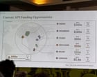
Imagine standing at a high-level global summit in Rio de Janeiro, talking about billions in health funding, and showing a map where Nigeria sits stranded in the middle of the Sahara Desert. That is exactly what happened to the U.S. State Department.
At the international AIDS conference, a presentation detailing health agreements under the President's Emergency Plan for AIDS Relief featured an absolute cartographic disaster. Every single country on the map of Africa was completely mislabeled. Mozambique was yanked across the continent to the Horn of Africa, the Ivory Coast lost its coastline entirely, and Cameroon vanished from the visual landscape while remaining textually listed.
High-level African delegates, including invited guests whose home nations were grossly misplaced, sat in the audience. They pulled out their phones, snapped photos, and shared the absurdity online.
How a Quick Slide Swap Exposed a Deep Flaw
The State Department quickly took full responsibility. Officials claimed a team member hastily swapped out the slide deck right before the presentation began. But the explanation did little to stem the PR fallout.
An analysis by Reuters uncovered an artificial intelligence watermark embedded in the graphic, pointing directly to OpenAI generation tools. Instead of using a verified, vetted geographical file from an internal repository, someone trusted a generative prompt to sketch out an entire continent.
Matt Petit of the Atlantic Council didn't mince words online, pointing out that whoever built and approved the slide simply didn't know basic geography and didn't bother checking their work. When you show up to a foreign policy event representing the United States and you cannot correctly place Nigeria—a nation where hundreds of U.S. troops are actively deployed—it sends a terrible signal.
The Real Cost of Lazy Tech in Diplomacy
We are seeing a dangerous trend of automated shortcuts bleeding into serious geopolitical spaces. Generative tools save time, but they hallucinate details constantly. Maps are notorious pain points for AI models. They scramble text, bend borders, and invent entirely fictional sovereign states out of thin air.
When a domestic blogger posts a bad graphic, it's a minor joke. When the Bureau of Global Health Security and Diplomacy projects an AI hallucination onto a massive screen in front of international partners, it crosses into diplomatic insult.
Aids expert Emily Bass put it bluntly on Substack, noting that the blunder felt less like an innocent typo and more like a careless disregard for international partners. Trust is hard to build in foreign relations and remarkably easy to lose.
Moving Past the Blame Game
The State Department apologized and reaffirmed its commitment to fighting HIV and AIDS globally. That mission matters. But the operational sloppiness threatens to overshadow the actual policy work.
If government agencies want to avoid going viral for all the wrong reasons, the fix is simple. Stop outsourcing basic visual verification to unvetted software. Pick up a real atlas, use verified government assets, and check the slides before walking onto the world stage.