Precipitation events exceeding local drainage capacities transform baseline topography into active transport channels for high-velocity debris flows. When severe thunderstorms track across the complex, unyielding terrain of the Appalachian foothills and the Ohio River Valley, the transition from meteorological anomaly to systemic infrastructure failure is near-instantaneous. The structural breakdowns observed across impacted regions underscore a critical vulnerability: modern emergency response and civil infrastructure remain uncoupled from the shifting thresholds of localized, short-duration hydrological shocks.
To evaluate why these flash flood events become fatal, the crisis must be analyzed through structural mechanics, terrain physics, and logistical failure points rather than treating it as an unavoidable natural disaster.
The Hydrological Equation: Runoff Acceleration Mechanisms
Flash flooding fatalities are directly proportional to the velocity and volume of surface runoff, which can be mathematically framed as a function of soil saturation levels, slope gradients, and localized precipitation intensity.
$$\text{Runoff Volume} = f(\text{Precipitation Rate} - \text{Infiltration Capacity})$$
The primary catalyst for sudden, destructive surges is the rapid exhaustion of infiltration capacity. In multi-day meteorological events, early rainfall waves saturate the topsoil layer, dropping the infiltration rate to near zero. When subsequent cloudbursts deposit intense rainfall—frequently measuring between 4 and 10 inches within compressed windows—the soil acts as an impermeable barrier.
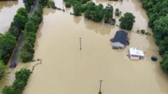
In highly dissected landscapes, such as the steep slopes and narrow valleys of eastern and central Kentucky, this immediate runoff enters a confined geographic bottleneck. The terrain functions as a physical funnel:
- Topographical Convergence: Rain falling across a broad upland drainage basin is forced down steep gradients into narrow, low-lying creek beds and hollows.
- Velocity Multipliers: As water volume is compressed into these narrow cross-sections, kinetic energy increases exponentially. The resulting torrents possess enough hydrodynamic force to dislodge vehicles, undermine asphalt, and shear residential structures from their foundations.
- Anthropogenic Alterations: Decades of land-use modifications, including historical surface mining and deforestation, have stripped away natural vegetation and topsoil. This leaves exposed bedrock or compacted earth, which drastically shortens the time-to-peak accumulation in local waterways.
Infrastructure Desynchronization and Civil Failure Modes
Civil infrastructure across rural and suburban corridors is built on historical hydrological data that no longer reflects modern precipitation extremes. When a critical threshold is breached, cascading failures disrupt physical and logistical networks.
The Linear Vulnerability of Transportation Systems
During intense convective storms, the rapid decommissioning of state and local roads cuts off vital evacuation routes and paralyzes initial response efforts. Roads built adjacent to low-lying drainage channels are vulnerable to immediate overtopping.
This asset failure is rarely localized; instead, it triggers a systemic network collapse. The submergence of low-water bridges and secondary routes creates physical blockages that isolate entire communities.
When structural components like culverts and drainage pipes are overwhelmed by hydraulic pressure and clogged with organic debris, water backs up and washes out road beds from beneath the pavement. This renders transportation networks unnavigable well before formal evacuation orders can be executed.
Geotechnical Degradation of Water Retaining Structures
The secondary threat vector during severe precipitation events is the destabilization of earth-fill dams and retaining embankments.
Excessive Rainfall ──> Soil Saturation ──> Pore Water Pressure Increases ──> Shear Strength Loss ──> Slope Failure / Landslide
When an earthen embankment faces sustained rainfall, the internal pore water pressure rises, severely reducing the shear strength of the soil matrix. This structural degradation often manifests as localized landslides along dam embankments.
While these initial failures do not always cause an immediate breach, they severely compromise the structural integrity of the asset. The risk profile shifts rapidly from a standard drainage issue to a potential catastrophic hydraulic release, necessitating preemptive evacuations of downstream populations.
The Logistics of High-Risk Hydrological Rescues
The transition from a localized weather event to a mass casualty scenario occurs when human transit intersects with active flash flood zones. A significant percentage of flash flood fatalities happen within vehicles, highlighting a critical gap in risk perception and public communication.
+--------------------------------------------------------+
|              HYDRODYNAMIC DISPLACEMENT RISK            |
+--------------------------------------------------------+
| 6 Inches of Moving Water   --> Loss of Vehicle Control |
| 12 Inches of Moving Water  --> Buoyancy/Buoyant Drift  |
| 24 Inches of Moving Water  --> Lateral Sweeping Flow  |
+--------------------------------------------------------+
An assessment of vehicle dynamics in high-velocity flows reveals that visual assessment of standing or moving water is highly unreliable, especially during low-visibility nighttime conditions. As water depth reaches the chassis of a standard passenger vehicle, buoyant forces begin to counteract the vehicle's weight.
At a depth of just 12 inches, most vehicles experience enough buoyancy to lose frictional contact with the road surface. Once contact is lost, lateral hydrodynamic drag forces easily sweep the vehicle into deeper, turbulent main channels, turning a stranded vehicle into a high-risk rescue operation or a fatal entrapment.
Consequently, search and rescue teams must pivot from proactive evacuations to reactive, high-risk water extractions. These operations demand specialized assets, including swiftwater rescue technicians, heavy high-clearance vehicles, and airborne extraction units.
The operational window for these interventions is exceptionally narrow. Deployments are routinely hindered by active electrical hazards from downed utility lines, zero-visibility conditions after dark, and the physical destruction of launch sites and staging areas.
Hardening Municipal and Rural Assets Against Hydrological Shocks
Addressing systemic vulnerabilities requires moving away from reactive post-disaster recovery and toward proactive engineering adaptations. Municipalities and state agencies must reassess risk profiles using updated, forward-looking hydrological models rather than relying entirely on historical data.
Priority must be given to upgrading critical drainage infrastructure. Culverts, retention basins, and storm sewer networks must be upsized to handle higher peak-flow volumes.
For earthen dams and critical embankments, installing advanced geotextile reinforcements and automated internal pore-pressure monitoring systems can provide early warnings of structural instability before visible landslides occur.
Simultaneously, transportation networks require targeted engineering interventions to maintain evacuation integrity. Elevating high-priority evacuation corridors and replacing vulnerable low-water crossings with clear-span bridge designs ensures that communities do not become isolated during sudden flash floods.
Implementing automated, sensor-driven road closure barriers at known low-lying inundation points can physically prevent drivers from entering high-velocity flow zones, significantly reducing the demand on emergency rescue teams during the critical opening hours of a flood event.